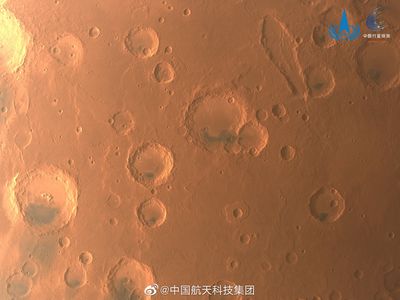
China has completed its global imaging of Mars, fulfilling the prime missions of the robotic spacecraft Tianwen-1.
The China Aerospace Science and Technology Corporation, the main contractor for the Chinese National Space Administration (CNSA), announced the success of the mission on the Chinese social media platform Weibo on Wednesday, June 29. The mission has managed to pick up medium-definition images of the entire planet, as well as a number of high-definition images that glow with details and vibrant color.

Named after an ancient poem titled "Heavenly Questions" in Chinese, Tianwen-1 was launched in July 2020 as the country's first independent interplanetary exploration mission. It consists of a six-strong gang made up of an orbiter, two deployable cameras, a lander, a remote camera, and the Zhurong rover.
After reaching Mars in February 2021, a “selfie” of the Zhurong rover and its lander was taken on the Martian surface using its remote camera and beamed back to its proud parents back in China.

Since then, the mission has been busy scanning and imaging the surface of the Red Planet, collecting 1,040 gigabytes of raw data through over 1,344 orbits. All of this juicy data, China says, will be made publicly available to scientists around the world in due course.
This includes a bunch of stunning high-resolution imagery, featuring vibrantly red pictures of some of the most important and intriguing corners of Mars.
Among the snaps is a catalog of imagery detailing the Valles Marineris (above), a colossal system of canyons that runs along the Martian surface for over 4,000 kilometers (2,500 miles), reaching depths of up to 7 kilometers (4 miles). It is unclear how this enormous scar-like canyon formed, but experts suspect that it started as a crack billions of years ago during the planet's cooling.

There are also images of the Martian south pole. This is an especially intriguing part of Mars because it’s home to a vast subglacial lake of salty water that could be our best shot at finding evidence of life on our planetary neighbor. Certainly, Tianwen-1 wouldn’t have picked up on any swimming Martians down there, but the images could potentially help inform scientists in the hunt for extra-terrestrial life.