Nature
 PUBLISHED



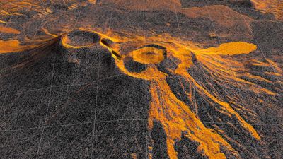


In December 2026, a US-Indian satellite started capturing images of lava as it flowed from a long dormant volcano pair on the Pacific coast of Russia’s Kamchatka Peninsular.
The satellite, the NASA-ISRO Synthetic Aperture Rader (NISAR), has recorded the changes in the local landscape twice every 12 days since then.
The volcano, located in the northern crater of Krasheninnikov, started erupting for the first time in nearly 500 years a few days after an 8.8 magnitude earthquake struck nearby on July 30, 2025.
The earthquake seemed sufficient to awaken a sleeping beast, which hadn’t erupted since 1550 CE. Lava has been steadily flowing eastwards from the northern volcano ever since.
The effects this geological event has had on the surrounding topography have been captured by NISAR’s detailed radar snapshots. Researchers have put 17 of the images taken through mid-August into a sequence that shows lava filling a smaller caldera before overflowing into a larger crater and then widening into a fan shape.
This animation demonstrations NISAR’s vantage point – 464 miles (747 kilometers) above the Earth’s surface – is ideal for monitoring developments of natural hazards, such as an erupting volcano, for both scientific research and for emergency responses.
A land of fire
Kamchatka is well known for its volcanoes. It is a very geologically busy part of the Ring of Fire, which is itself one of the most geologically active zones on the planet.
There are over 300 volcanoes on the one peninsular alone, though only 29 are currently active. Many of these active volcanoes are closely monitored by ground instruments because they erupt so frequently.
However, Kraseninnikov was largely ignored because it has been quiet for so long.
NISAR is able to record such detailed snapshots of the volcanoes activity as it firstly passes south to north, and then again as it passes north to south. It is the first satellite to carry two synthetic aperture radars (SAR), a specialized processing technique first created by NASA’s Jet Propulsion Laboratory in Southern California.
“The consistency is crucial. Twice every 12 days, acquiring in this high-resolution mode and in two observation directions, this shows the promise of NISAR to closely monitor natural hazards,” Matthew Pritchard, a member of the NISAR science team and geophysicist at Cornell University, explained in a statement.
How to capture a volcano
As the satellite orbits, the radar transmits thousands of microwave pulses per second down to the Earth’s surface and then receives the signals as the bounce back.
Each of these are effectively a snapshot in time, containing data about the properties and characteristics of terrain below. NISAR collects these signals using its giant drum-shaped reflector – the largest radar antenna reflector NASA has sent to space.
The SAR processing merges many images of the same area to form sharper views of its subject, just like a lens can sharpen a blurry object being focused on. Each pixel in the individual frames of the time-lapse represent around 10-meter-by-10-meter (30-foot-by-30-foot) square on Krasheninnikov’s surface.
NISAR is the first free-flying space mission to feature two radar instruments – an L-band system and an S-band system.
They are both completely complementary due to their respective wavelengths. The L-band can pass through tree canopies, capturing the ground below, while the S-band can observe the leaves of the canopy itself (depending on their size).
In addition to the lava fields appearing in the east, the time-lapse also reveals a flow to the northwest, which may have formed before NISAR captured the first images. The lava appears lighter in the image due to how microwaves bounce off of it compared to surrounding surfaces.
Improvements in these monitoring technologies has transformed how we view all the planet’s roughly 1,300 active, above-sea-level volcanoes.
“We’re seeing volcanoes around the world that we’ve never really had eyes on like this before,” Pritchard added.